Everest Is NOT the World's Tallest Mountain!
First, let's be clear: Mount Everest is the world's tallest mountain—as long as you measure from sea level, which has been the custom.
First, let's be clear: Mount Everest is the world's tallest mountain—as long as you measure from sea level, which has been the custom. This article aims to explain why this practice was adopted and to tell a bit of the history behind these measurements and their interests.
A bit of history
Measuring mountains from sea level was fine a few centuries ago. After all, it was relatively easy to do, because scientists could measure atmospheric pressure at a given location with a barometer, and calculate the elevation of that place relative to sea level with a simple formula. Most altimeters, even today, work this way. There are a number of additional variables that can influence the calculation, such as pressure variations, temperature, latitude, etc., but for practical purposes the result was acceptable. That's why the elevations of places began to be measured this way.
But there was a problem: to measure the altitude of a mountain with this method you had to carry a barometer to its summit. Today, mountaineers usually carry one in their pocket, but imagine about two hundred years ago when the highest mountains were first being measured and the measurement equipment consisted of precarious, fragile, bulky, and heavy contraptions, some the size of furniture. Sometimes scientists had to haul their equipment with the help of mules, horses, and even people. Long caravans of assistants accompanied the scientific missions of yesteryear. Because of these difficulties, to measure the height of the highest mountains, they didn't reach the summit itself, but rather got to a certain point from which the peak of the mountain could be seen, measured its barometric height, and from there, using topographic methods, employing some optics and calculating angles, determined the remaining height.
The methods described above have been used from long ago until today and were also used in 1802, when the United Kingdom initiated its topographic survey project in its colonies of the East Indies, where Everest was located.
It turns out that in those days, Everest wasn't even called that. Local inhabitants called it Chomolungma (actually, this is the westernized name), and despite its current fame, back then it was just another peak; so much so that the British expeditionaries in charge of the topographic project of the Indies (Great Trigonometrical Survey) had catalogued it as Peak 15. With no more sorrow or glory than that of a number—not even number one, but just another number.
Continuing with the history behind the measurements and their interests, it's important to highlight that Mount Everest became the world's tallest mountain primarily due to the work of the Great Trigonometrical Survey, a topographic project carried out by the United Kingdom in its East Indies colonies in the 19th century. At that time, Everest didn't bear that name, but was known as "Peak 15," a simple number without any special significance.
The Great Trigonometrical Survey, led by the distinguished British surveyor Sir George Everest, had as its main objective to make precise measurements of the mountains in the region. However, due to the technical and logistical limitations of the era, the scientists were unable to reach Everest's summit to take direct measurements of its height. Instead, they carried out barometric measurements and used topographic methods to determine the remaining height.
The work of the Great Trigonometrical Survey was an impressive feat for its time and laid the groundwork for future altitude measurements around the world. However, it's important to note that these measurements were based on the sea level reference, a common practice at that time that has endured to the present day.
Everest has been considered the tallest mountain since the 19th century
Since then, Everest has been widely recognized as the world's tallest mountain. Its prominence and majesty have made it an iconic symbol of human achievement and a challenge for mountaineers around the world. However, if we consider other references for measuring the height of a mountain, we find that there are other equally impressive contenders.
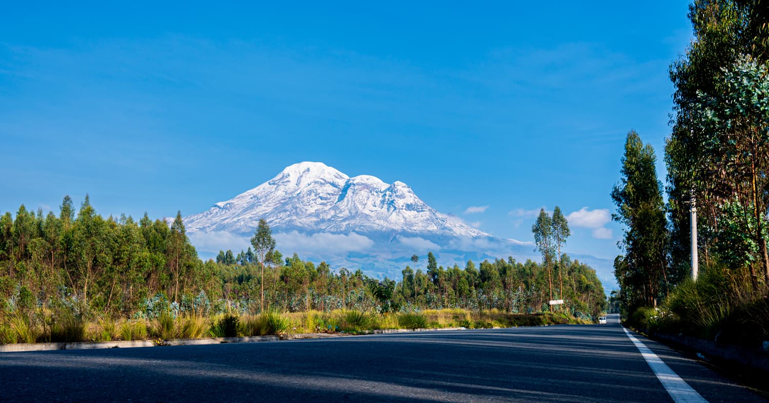
If we measure the height of a mountain from the center of the Earth, taking into account the ellipsoidal shape of the planet, we find that Mount Chimborazo, in Ecuador, rises as the world's tallest mountain. This is because the Equator is closer to the center of the Earth compared to the poles, due to the planet's flattened shape at the poles and bulging at the equator. As a result, the summit of Chimborazo is farther from the center of the Earth than the summit of Everest.
The world's tallest mountain is Chimborazo, in Ecuador
Mount Chimborazo, with an altitude of about 6,263 meters above sea level —according to the 2016 satellite measurement—, may seem inferior compared to Everest's impressive 8,848 meters. However, if we take into consideration the radius of the Earth and the way height is measured from the center of the planet, Chimborazo rises imposingly as the tallest mountain.
This perspective demonstrates how the choice of reference used to measure the height of a mountain can lead to different conclusions. Everest, with its widespread recognition as the world's tallest mountain, is based on measurements taken from sea level, a widely accepted convention. On the other hand, if we consider the measurement from the center of the Earth, Chimborazo claims its title as the tallest mountain.
It's important to keep in mind that both Everest and Chimborazo are natural wonders and each possesses its own distinctive grandeur and beauty. The choice of which is the world's tallest mountain depends on the context and the reference used to measure its height.
In conclusion, Mount Everest is considered the world's tallest mountain when measured from sea level, a practice established centuries ago. However, if we consider the measurement from the center of the Earth, Mount Chimborazo, in Ecuador, rises as the tallest mountain due to the ellipsoidal shape of the planet. Both perspectives are valid and allow us to appreciate the diversity and complexity of our planet and its natural wonders.
Below are some articles that address the topic with a similar approach:
- https://www.bbc.com/mundo/noticias/2016/04/160407_por_que_chimborazo_ecuador_mas_lejos_centro_tierra_que_el_everest_dgm
- https://www.nytimes.com/es/2016/05/20/espanol/quitate-everest-el-volcan-chimborazo-en-ecuador-es-la-montana-mas-alta-del-mundo-segun-como-se-mire.html
- https://elpais.com/elpais/2016/04/06/media/1459968136_940253.html
References:
- Kargel, J. S. (2004). Everest: A topographic playland. Geotimes, 49(6), 12-15.
- Brown, D. (1994). The Story of Maps. Tormont Publications.
- James, G., & Everest, M. (2003). George Everest: Geodetic explorer of the Himalaya. Survey Review, 37(291), 342-352.
- de Ferranti, J., Maizlish, A., Maizlish, N., & Hawley, W. (2001). The height of Everest. WorldMountaineering.com.
References
- NOAA, National Ocean Service, "What is the highest point on Earth as measured from Earth's center?", Ocean Facts, oceanservice.noaa.gov. oceanservice.noaa.gov
- Instituto Geofísico de la Escuela Politécnica Nacional (IGEPN), "Equipo franco-ecuatoriano colocó un GPS en la cima del volcán Chimborazo", Quito, February 2016 (IGEPN–IRD France–IGM Ecuador mission). igepn.edu.ec
- B. L. Gulatee (Survey of India), "Mount Everest: Its Name and Height", The Himalayan Journal, vol. 17, 1952. himalayanclub.org
Categories
The books · born from this blog

Atahualpa con su abrigo de pelo de murciélago
y otras 49 historias verdaderas que parecen mentira
Available on Amazon
Tocar madera
Pequeña historia de las supersticiones que el mundo no ha podido soltar
Available on Amazon
100 futuros
Cien escenarios del mundo que viene con la inteligencia artificial
Available on AmazonYou may also like

Knock on Wood: The Real Origin of the Superstition
Almost everyone thinks knocking on wood comes from Celtic tree worship. But the documented trail leads to a far more recent origin: a children's game.

Stockholm Syndrome Was Born to Silence a Hostage
The famous syndrome didn't come from a study: the police's own psychiatrist coined it to discredit a hostage who criticized him. It isn't in the DSM.
The Fifth Sleep: when we slept in two shifts
For centuries we did not sleep eight hours straight, but in two sleeps with a waking hour in between. The history of segmented sleep, from Cervantes to science.